Overview
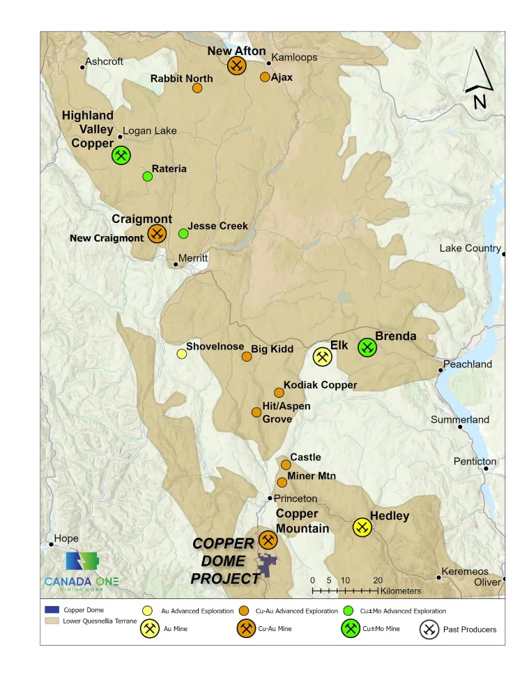
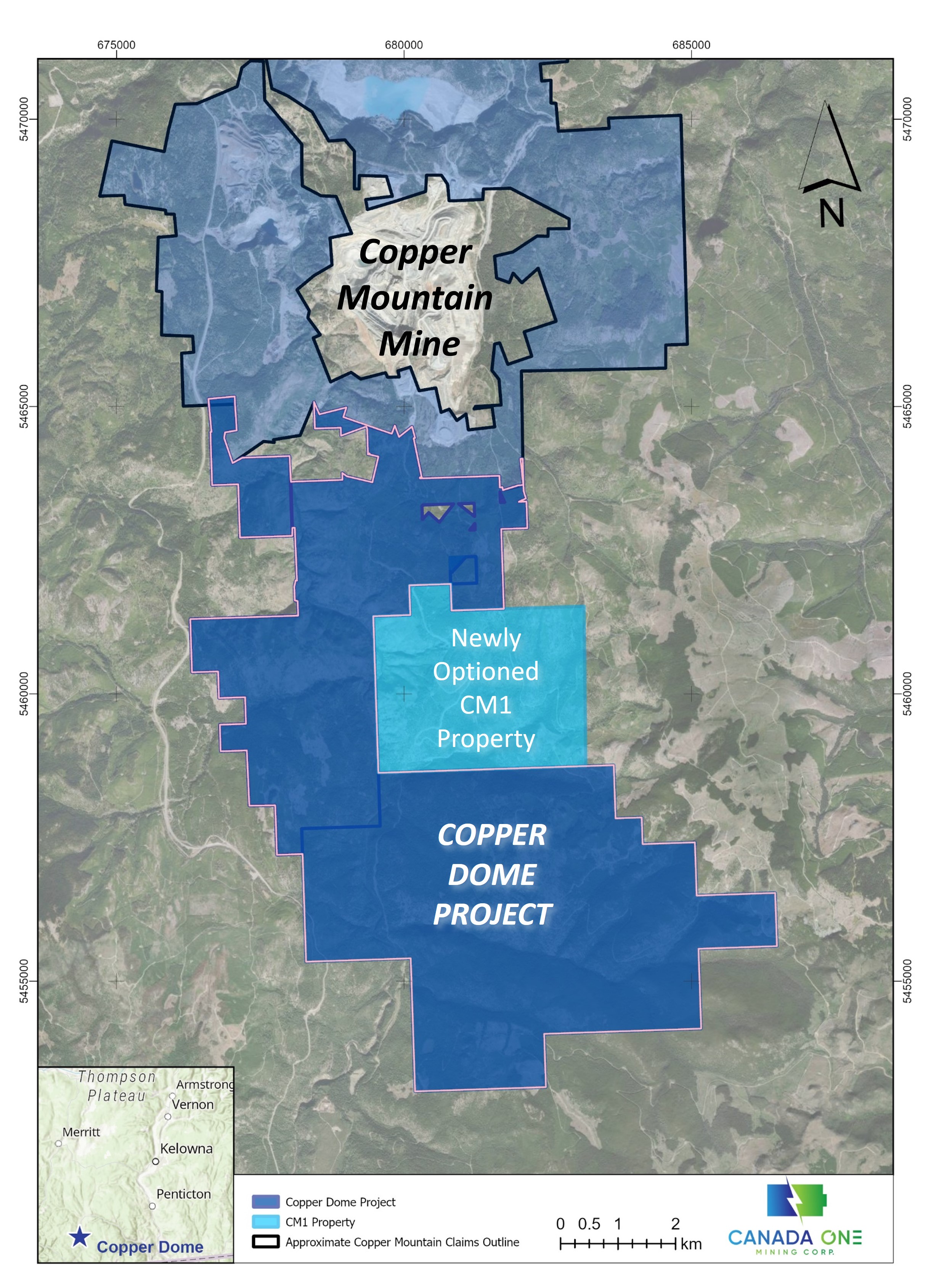
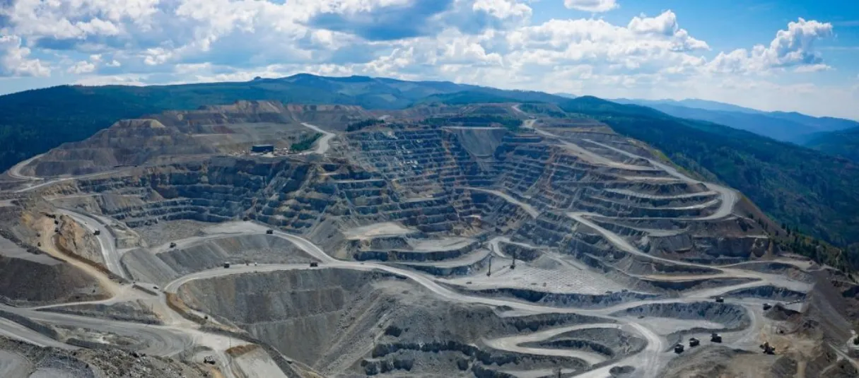
Canada One is exploring its 100% owned Copper Dome Project located 18 km south of Princeton, British Columbia and contiguous to the Copper Mountain Mine, owned and operated by Hudbay Minerals Inc (TSX:HBM). The northern boundary of the project lies roughly 1.5kms from the Copper Mountain deposits.
The Project has seen exploration over the years including magnetics and induced polarization geophysical surveys and several rounds of diamond drilling. Canada One has a large land package with several drill ready targets.
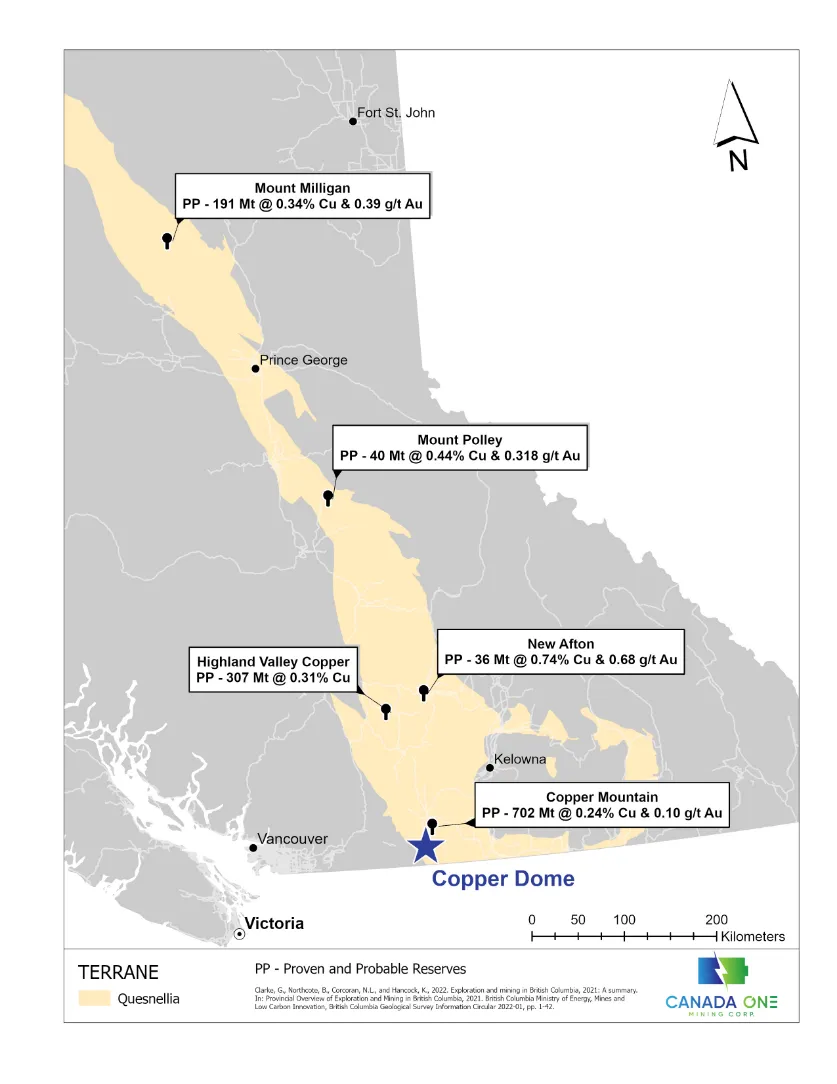
Leading Exploration in The Quesnel Trough
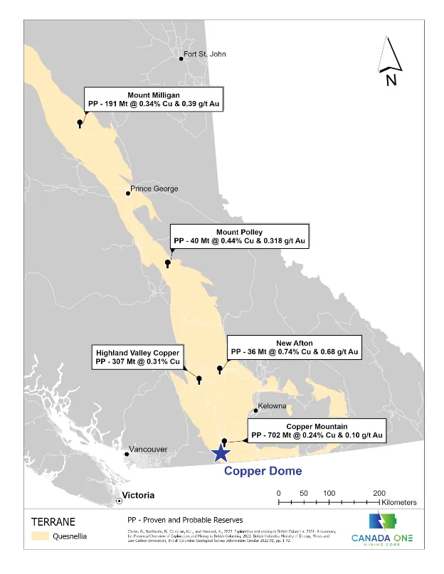
The Copper Dome Property is Located 18km South of Princeton BC - approximately a 3 Hour Drive from Vancouver, BC
The Project lays within the lower portion of the Quesnel Trough Porphyry Belt.
The Project is contiguous to the south of the producing Copper Mountain Mine
All Infrastructure is in place for potential future mining operations given the proximity to Copper Mountain Mine
Location allows for year-round exploration
Ease of access assists in keeping explorations cost low and on budget
| The Quesnel Trough is once again an intense area of interest for staking, exploration and discovery |
In a World-class Porphyry Belt Next to a Mine
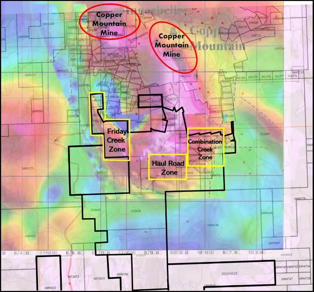
Copper Dome’s northern border lies 1.5 kms from the producing Copper Mountain Mine open pits
Copper Mountain has Proven/Probable – 702 MT @ 0.24% Cu, 0.09 g/t Au and 0.72 g/t Ag (www.hudbayminerals.com)
The Company has an ability, and intents to expand the land package
The northeast running geological structures at Copper Dome are similar to those seen at Copper Mountain
Argillic style alteration seen adjacent to the Open Pit at Copper Mountain are also noted at Copper Dome
| Best place to look for a mine is next to a mine |
Mineralization & Geology
The Copper Dome is located within the larger Copper Mountain area and part of a structurally complex, alkalic porphyry copper-gold system where historical mining operations from 1927 to 2019 have produced approximately 1.7 billion pounds (Blb) of copper, 700,000 ounces (oz) of gold, and 9 million ounces (Moz) of silver. Most of the copper-gold mineralization at the Copper Dome Project and at the mine site is in the form of veins, fracture fillings, and disseminations within volcanic rocks of the Nicola group and intrusive rocks of the Lost Horse intrusive complex. (reference source)
The Copper Mountain deposit is classified as an alkalic porphyry copper-gold deposit. Alkalic porphyry deposits typically have low-pyrite and high-carbonate contents, and therefore have a low probability of issues with acid-rock drainage.
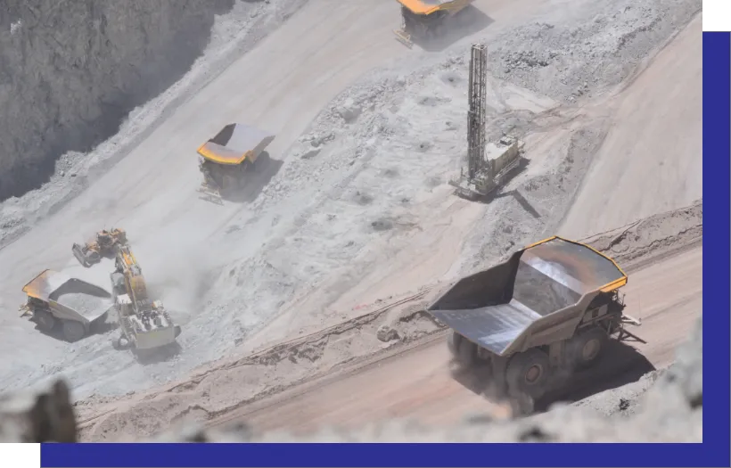
The Copper Mountain Mine, which is contiguous to the north of Canada One's Copper Dome Project, is a conventional open pit, truck and shovel operation. The mine has a 45,000 tonnes per day plant that utilizes a conventional crushing, grinding and flotation circuit to produce copper concentrates with gold and silver credits. A new life of mine plan to expand the mill to 65,000 tonnes per day, further increases average annual production to 138 million pounds of copper equivalent and reduces all-in costs to US$1.76 per pound of copper over the first 20 years of a 32-year mine life. The 65,000 tonnes per day mill expansion, including the integration of New Ingerbelle, brings Copper Mountain Mine’s after-tax NPV at an 8% discount to US$1.245 billion (see Life of Mine Plan Expansion Study Technical Report, Copper Mountain Mining Corporation, Sept. 2022). Further potential exists through the upgrading of Mineral Resources to Mineral Reserves and further exploration to continue to extend the mine life and add value.
The Company cautions the discoveries and observations on properties in proximity to the Company’s properties are not necessarily indicative of the presence of similar mineralization or geology on the Company's properties.
Zones & High-grade Mineralization
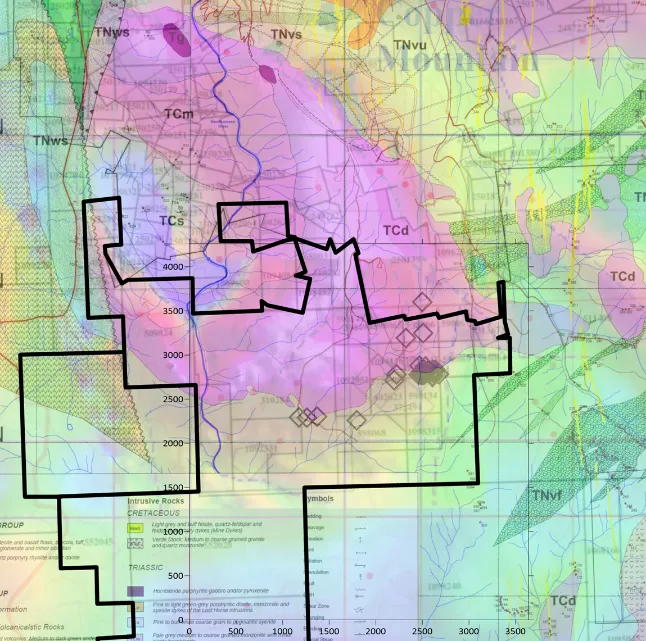
- Area on both maps colored pink corresponds to High Magnetite content in the Copper Mountain Stock
- Mineralization appears to be confined on the contact between the Nicola Volcanics (Interpreted as Low Mag in yellow) And The Copper Mountain Stock (Interpreted as a high mag in pink)
- The majority of known mineralization follows this trend In the Copper Mountain Camp
- Potential for High Grade Mineralization exists on the property:
- In 2009 High Grade Rock Samples Returned Values of 43% Cu 28.16 g/t Au and 18.19 gt/ Pd. A 3 Meter Chip Sample from this Showing Assayed 15.76% Cu 12.26g/t Au and 10g/t Pd (Minfile 092HSE033)
- In 1960 Property Owner Hamelin Sampled 79 Feet of 1.25% Cu and 42 Feet 0.26% Cu as well as 12 Feet of 1.30% Cu on the Copper Dome Project (Minfile 820902)
- Limited Access due to Drill Permitting Issues hindered Exploration In the Past and limited exploration drilling
Historic Drilling Highlights
Combination Creek
| Drill hole | Length (m) | Cu% |
| DDH PT-10-01 | 50 | 0.15 |
| DDH PT-10-02 | 45 | 0.17 |
| including | 22 | 0.23 |
| DDH PT-10-17 | 19.5 | 0.71 |
| including | 2 | 4.08 |
| including | 1.25 | 6.44 |
| DDH PT-11-16 | 40 | 0.19 |
| including | 4 | 0.28 |
| DDH FC-18 | 102 | 0.13 |
| including | 6 | 0.28 |
| DDH PR-12-26 | 20 | 0.64 |
Friday Creek
| Drill hole | Length (m) | Cu% | Au g/t |
| DDH FC-01 | 8 | 0.55 | 2.8 |
| DDH FC-02 | 15 | 0.32 | 0.98 |
| DDH FC-11 | 156 | 0.08 | - |
| including | 10 | 0.71 | 0.76 |
| DDH FC-12 | 42.5 | 0.28 | - |
| including | 6 | 1.5 | 0.7 |
| DDH FC-14 | 18 | 0.20 | - |
| DDH FC-15 | 17 | 0.17 | - |
| DDH FC-16 | 13 | 0.14 | - |
| DDH FC-17 | 17 | 0.21 | 0.04 |
Represents drillcore lengths, true widths are unknown. The drilling was done to the standards of the time and are considered “historical” in nature and cannot be considered 43-101 compliant and should not be relied upon. The results are listed here to show why the Company is interested in this area. Future work and drilling may not repeat similar results.
| Historical drilling confirms the presences of high-grade copper with gold credits |
Road Haul Zone – Prior Drilling Missed A High-Chargeability Anomaly
- Hole PT-11-13 Drilled to a Depth of 502 meters/Drilled South East at a -85 DIP/from 6m to 500m hole averaged 0.0198 % CU/ Drilled on Edge of High Chargeability
- Hole PT-11-14 Drilled to a Depth of 505 meters/Drilled South East at a -85 DIP/from 35m to 500m hole averaged 0.023% Cu/ Drilled on Edge of High Chargeability and Medium Chargeability
- The Main IP Chargeability Zone is 300M by 450m/ 30MS to 35MS +
- Medium Chargeability Zone is 800M by 600M /10MS to 29MS
- Main IP High Chargeability Target never Drilled / Several Other High Priority Targets Never Drilled as Outlined By Interpretation report SJ Geophysics
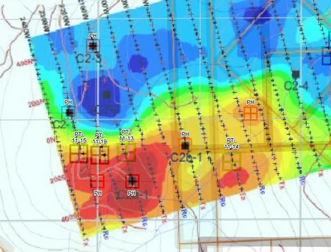
| Holes PT-11-13 and PT-11-14 confirm the of long intervals of anomalous copper mineralization |
Project Specifics
Driving news that will move markets
Phase 1 Exploration Budget
Primary focus will be identifying drill targets.
The latest geophysics technology and data compilation will be used to identify target locations:
1. Data Comp/Sampling/Geophysics
- $300K
2. Drilling – 2000 M – 6 holes
-$600K
Royalty
There is a 2% Net Smelter Royalty (NSR) on the project.
The royalty is as follows:
2% NSR:
with a first option for the Company to purchase 1% for $100,000; and
a second option for the Company to purchase the remaining 1% for $300,000.
Project History
Work completed to date, beginning in 1960 on the Property, consists of four drilling campaigns totaling around 11,000 m in 66 holes. In addition, 2,253 soil and 378 rock samples have been collected. Geophysical surveys include 281 km of ground magnetics, 114 km of induced polarization and 86 km of ground electro-magnetics.
In 2007, diamond drilling was performed by the Company on the Friday Creek zone in the northwest corner of the Project. Hole DDH FC-12 returned 42.6m of 0.28% Cu including 6m of 1.5% Cu and 0.7 g/t Au. Hole DDH FC-11 returned 156m 0.09% Cu including 10m of 0.7% Cu 0.8 g/t gold (AR 33852).
The Combination Creek zone located within the northeast corner of the Project shows stockwork veining associated with hornfels within the volcanic and sedimentary rocks adjacent to the Copper Mountain stock. The best mineralization in the Combination Creek zone drilled to date is found in a 70 to 100 m wide section of Nicola volcanics bounded to the north by the Copper Mountain Stock and to the south by a coarse pink feldspar porphyry syenite dyke.
Drilling by the Company in 2010 and 2011 in the Combination Creek Zone returned the following highlighted intercepts (AR 33070):
- DDH PT-10-01: 50 meters of 0.15% Cu, including 12m @ 0.28% Cu.
- DDH PT-10-02: 45 meters of 0.17% Cu, including 10m 0.44% Cu.
- DDH PT-11-18: 102.7 meters of 0.14% Cu including 6m 0.29% Cu.
Stay Informed
Sign up to receive our latest news releases from the Canada One Mining Corp. team.

